North and West Africa. The last 200 Years. Regeneration and Desertification
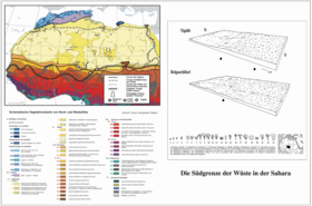
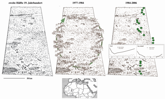
The landscape descriptions of 19th, century explorers are accurate enough to produce vegetation maps. The travelers agreed that the essential boundaries of the Sahara were stable and resembled those of today. They described dense forests instead of present-day savannahs and emphasized the character of cultivated landscapes for the present-day Sahel and for large areas of the Sudan. They also emphasized the enormous density of large mammals. Essential, however, were the steady and wide grass and herbaceous areas in the Sahara. They allowed the nomads to increase the herds and to develop their social position.
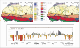
From the same sources, it was also possible to obtain a precipitation chronicle, which is presented here in parallel with the maps. From about 1870 to 1970 there was a wet season, although interrupted by droughts. With the droughts beginning in 1970, many economic systems collapsed as overstocked herds could no longer find pasture or cropland had to be cut back. Overexploitation and its damage fed the belief that these were irreversible developments. Measures were taken to protect the regions, for example supra-regional forest belts.
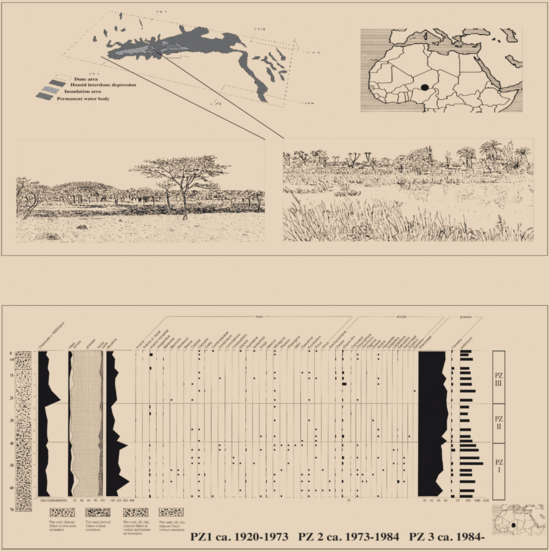
Nevertheless, there were many indications of the still existing regenerative capacity of vegetation and soil. It was possible to work with them. The pasture and well rotation system of R. Reichelt (1989) in the Gourma of Mali was able to feed the herds and prevent the destruction, which became visible as desertification all around, by the acceptance of the local population until 1984. Only by the incursion of nomads from the north, who did not accept the arrangements. Long-term observations in the same region showed the still existing regenerative capacity of vegetation and soil, although with long waiting periods. However, a pollen diagram shows that the floristic diversity in the Sahel has not been regained after the drought of the 1970s.
The Gourma System in Northern Mali Between the Niger Arc and Hombori
The region exemplifies the extensive acacia forests of the Sahel. The lack of springs and wells made pasture use limited in the 19th century. Nevertheless, there were three types of cultivated landscapes. Nomadism and grazing in the north and along the flood lakes of the Niger, cropping/gardening around the Hombori stage, and that of elephants. Large herds were able to reshape vast areas according to their needs.
In the 20th century, new wells led to extreme overgrazing. In agreement with the local /regional population, a rotational system of grazing and wells open only for short periods of time worked to conserve pastures and prevent the desertification phenomena of the surrounding regions. It was not until 1984 that this system collapsed. Long-term observation series thereafter proved the regenerative capacity of vegetation and soil-depending on the substrate. However, this work had to be abandoned because of the great insecurity in the region.
The Different Approaches to Regeneration
Large-scale forest belts (Great Green Wall, Escadafal 2011) as opposed to long-term local projects that can be supported by the respective population (Ousseini 2009). The Great Green Wall is currently failing due to general insecurity. However, work on the symbiosis of acacia and root bacteria continues. The experience of colleagues in Niamey shows that after advanced degradation and soil erosion, only complete and long-term cultivation of the region can lead to regeneration. One insight from this is that continuity and staying power are needed.

Literature (Selection)
- Hiernaux, P., Diarra, L.,Soumagel, N., Lavenu, F., Tracol, Y., Diawara, M. 2009: Sahelian rangeland response to changes in rainfall over two decades in the Gourma region, Mail. Journal of Hydrology, 371, 1-2. 114-127.
- Escadafal, R. 2011: Le projet africain de Grande Muraille Verte. Quels conseils les scientifiques peuvent-ils apporter? Dossier d´actualité.CSF-desertification.org/ grand-muraille –verte. Montpellier, 45 p.
- Ibrahim, S., Schulz, E. 2017. An der Quellen der Angst. Der Bohrkern von Guidimouni. Z-Blatt Geol.-Paläontol. Im Druck
- Nicholson, S. E., Dezfuli, A. K. und Klotter, D. 2012: A two-century precipitation data set for the continent of Africa. Ann. Meteorol. Soc., 93, 1219–1231
- Ousseini, I 2000: Erosion et conservation des sols dans la vallee du Moyen Niger (République du Niger): intrpretations préliminaires de mesure en parcelles et d´observation a l´echelle de petits et moyens bassins versants. In: Hori,N. (ed.) Human response to drastic change of environment in Africa II, Tokyo, Metropolitan University, 39-70.
- Reichelt, R. 1989: L’Hydraulique Pastorale et la Desertification au Sahel des Nomades en Afrique de l’Ouest –Réalités et Perspectives, Geologisches Jahrbuch, C, 52, Stuttgart, 32 pp
- Schulz, E., Abichou, A., Adamou, A., Ballouche, A., Ousseini, I. 2009: The desert in the Sahara. Transitions and boundaries. In: Baumhauer, R. and Runge, J. (eds.) Holocene Palaeoenvironmental history of the Central Sahara. Palaeoecology of Africa, 29; 63-89.
Contact & Links

Sani Ibrahim teaches and conducts research at the Département de Géographie at the Université de Niamey, Rep. Du Niger. Geographic fields of work: Landscape history, resource management.

Dr. rer. nat. Prof. h.c. (Cluj) Erhard Schulz teaches and researches at the Institute of Geography and Geology at the University of Würzburg. Geographic fields of work: Landscape and vegetation history.


