Mapping in West Africa from Space
The availability of area-wide maps and data is very low in West Africa. Several reasons can be cited for this: (i) the unfavorable development of the countries in the region, (ii) recurrent regressions due to crises such as revolts or diseases, and (iii) a lack of experts. Remote sensing can help address these issues.
Satellite imagery provides a freely accessible data base from which mapping can be done. To create such maps, usually only a few site visits are necessary, during which information about the space can be obtained, which is then cross-checked with the satellite images.
Agriculture in West Africa
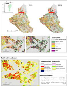
In the countries of Burkina Faso, Ghana and Benin, satellite imagery was used to map the distribution of crop types within selected study areas in very high spatial resolution. In a first step, agricultural areas are identified (Fig. 1). Based on these maps, crop types are mapped in a subsequent step. Comparing these detailed maps from different years, it is even possible to derive information about crop rotations (Fig. 2).
Urban Mapping
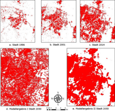
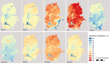
The worldwide trend toward urbanization can also be observed in West Africa. Rural exodus and a high birth rate are causing cities to grow rapidly. Maps showing the past growth of cities and, in addition, estimates of future expansion are therefore in high demand. Satellite imagery can be used to generate information on past growth (Fig. 3), and based on this, potential further expansion can be modeled. In addition, further information, such as the annual variation of the surface temperature of a region (Fig. 4), or a further subdivision of the urban area can be displayed.
Contact & Links
Dr. Michael Thiel holds a degree in Applied Environmental Science from the University of Trier, Germany. In 2013, he received his PhD from the University of Jena on the use of texture information of high-resolution SAR data to describe settlement areas. As a research associate at the Chair of Remote Sensing at JMU, he is currently researching and teaching on land use in West Africa.


